Category: National Parks

  • That’s WY: Yellowstone National Park Lamar Valley

    That’s WY: Yellowstone National Park Lamar Valley

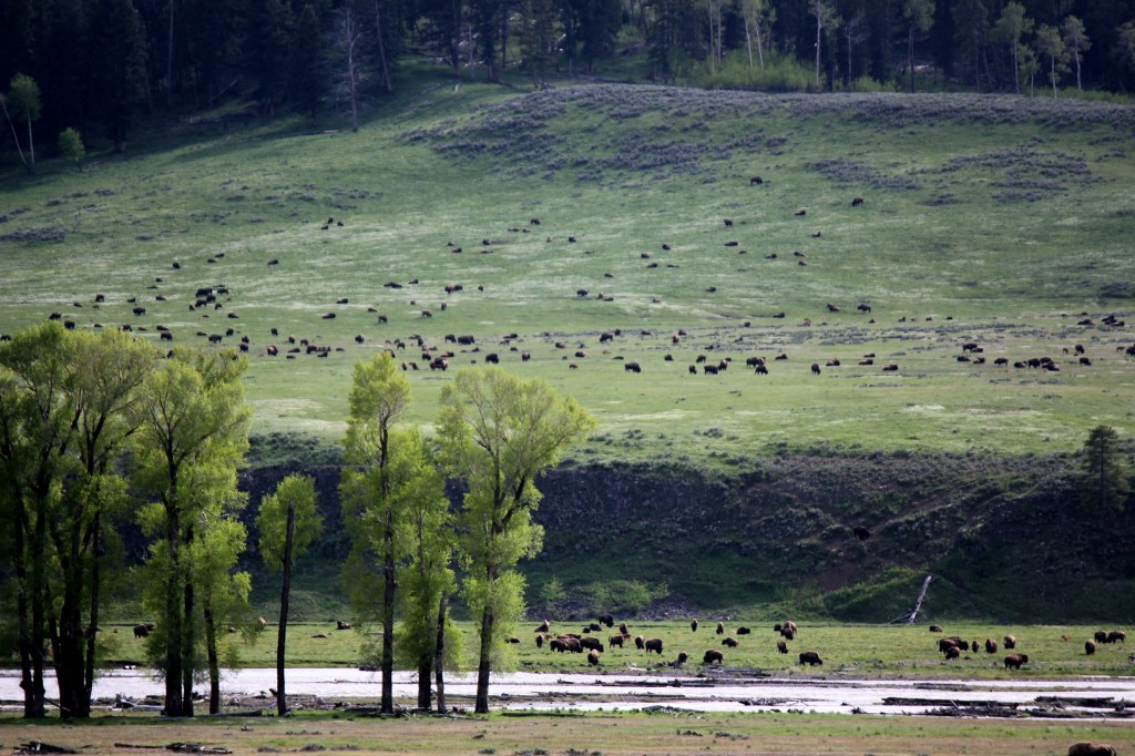
    If there is a place left in our country where the buffalo do roam and the deer and antelope play it is in the northeast corner of Yellowstone National Park in Lamar Valley.  If animal sightings are high on your Yellowstone bucket list then a visit to either Lamar Valley or Hayden Valley are a must.

    The most controversial resident in these two areas is the wolf. Yellowstone re-introduced wolves in 1995 and currently there are eleven packs with an estimated count of 108 wolves living in Yellowstone and nearly 530 in the larger area.  A casual tourist driving through these areas is more likely to find a wolf enthusiast camped out along the road than they are a wolf in the fur.

    In addition to the wolves, many other animals can be seen in these two areas. Pronghorns, elk, coyotes, big horned sheep, moose, bison, bald eagles, osprey, bears, and even badgers. Of course spotting these animals can take a keen eye or you can just follow your intuition. When you see a group of people pulled over looking off in the distance, you can stop and ask what they are looking at. You will find that not only are they eager to share their find with you but they are also likely to share their spotting scope as well.

    Early Bird Gets The Worm

    One morning during our visit to Yellowstone, we sat our alarms and took off as the sun was rising to make the long drive from Fishing Bridge to Lamar Valley. Our children were very grumpy and nearly at melt down stage before we even got started. Thankfully, our efforts were rewarded just a few miles from our campground when we spotted a large 400 + black bear running across the road. We were able to stop, pull off the road, and watch this animal cover a ground like he was Jack Be Nimble. There is nothing like seeing a giant black bear to push away the excitement and change a little persons attitude from grumpy to eager explorer.

    We made a stop by The Petrified Tree as we had heard rumors from other visitors of Moose sightings in that area. We never saw a Moose so we headed off to Lamar Valley.  Shortly after we turned off the grand loop onto Highway 212, I noticed a new animal butt. Wayne thought it was a elk but I had seen my fair share of elk butt’s during this trip and this butt was definitely different. So, we pulled over and set about to explore. Again we were rewarded with a herd of Big Horn Sheep.

    Our animal sightings continued; we found a badger, eagles, and even a momma elk teaching her newborn how to run. We sat and watched this new baby stumble, get up, run, stumble, get up, and run until they were no longer visible. The one animal we had hoped to see but never saw was the Moose.

    Our activity goal in Lamar Valley was to hike to Trout Lake. We found the parking lot to be small and very crowded. The hike from the trail head to the lake is not a long one but has a very challenging vertical rise. We did make it to the lake and again we were rewarded with a beautiful view of mountain peaks reflecting on the lake. We were surprised to find fly fishermen fishing in Trout Lake. Wayne had researched in and thought the lake was off limits to fishing. We learned that only one small part of the lake, the outlet where the trout spawn, was off limits.

    After a good hike and successful animal sightings we allowed ourselves a picnic lunch at the Yellowstone River Picnic area. A very friendly fox made his appearance during our lunch, which allowed us to have great conversations about the side effects of feeding wild animals with the kids.

    People Love Sharing Their Passion; So Don’t Be Afraid to Strike Up a Conversation

    The Todd’s loved Lamar Valley, in fact it was probably one of their favorite places in Yellowstone. They also had great animal sightings and were lucky enough to see the Moose near the Petrified Tree. The Todd’s learned that the visitors camped along the road are serious about their animal sighting and they are eager to share their passion with others.

    Despite an early start to our day and despite the distance between our campground and Lamar Valley, we decided to return to Lamar Valley that evening in hopes of spotting a few more animals on our bucket list.


    Off Highway 212, is a dirt road leading to Slough Creek. We traveled down that road and found a large group of wolf enthusiast camped out with powerful spotting scopes. We also learned they were watching a wolf den about 2 miles west of where we were standing. Waiting to see these animals is part of the game. These wolf enthusiast are prepared to wait Our little girls on the other hand find boredom really quickly.  In an attempt to distract, Wayne took the girls for a hike down to Slough Creek. Funny, on their hike, they disturbed a coyote who then walked right in front of the wolf enthusiast and they barely saw it. They were looking two miles past that ole coyote.

    Our binoculars were not sufficient and we were thankful our host invited us to use their spotting scopes. Having poor eye site and needing corrective lenses I had little hope that I would be able to maneuver my glasses and the scope and be successful in seeing anything. Our host were so gracious and kept letting me try. I had probably tried three or four times and never saw a thing. I felt so inadequate because everyone else who looked through that scope got so excited. Not me. I could make out from where we were standing the den, or the general area but we were so far away and things just looked liked dots. Then, our host patiently offered me one more look and I was able to see the den and the wolf pups playing outside of it. I felt such a sense of mastery when I was able to figure out how to use that scope and got to see those pups (that looked just like dogs by the way).

    Persistence Pays Off So Don’t Stop Believing

    As much as Allen wanted to see the wolves, I wanted to see a Moose. Rumors haunted me all day of a momma Moose and her baby being spotted along Soda Butte Creek north of Soda Butte Cone. We decided to part ways with the wolf enthusiast to go in search of a Moose. As we traveled Northeast on 212 every finger was crossed that we would be lucky. We kept hearing the momma and her baby lingered in the creek so I kept following the river. It went from wide and slow to narrow and rushing.

    We finally turned a corner, the river changed again and we saw all the people lined up along the road. There was a Moose off in the distance eating. I think I slide out of the truck before Wayne even had it stopped. Before I could blink, Angie and the kids were right there. We sat and watched her for a long time and then without warning her baby emerged from the brush. A collective “awww” rose from the small crowd who had gathered. I was so excited I sat in utter amazement forgetting to take photographs!

    The Icing On The Cake Is So SWEET

    We left Lamar Valley to head back to camp with our head and hearts happy. What a day! We started off with a bear, then big horned sheep, then a badger, an eagle, a fox, wolves, and finally a moose. My Yellowstone Vacation was officially complete. We decided to stop by Tower Falls.

    However, before we could get to Tower Falls, traffic stopped and began backing up. This is usually a really good indicator of an animal sighting. However, the only animal we could see was a bison, which are so plentiful you honestly stop stopping for them after your first day in the park. Before we could even process that this crowd was forming for a bison, we saw a momma bear and three cubs frolicking in the trees near the bison. The bison moved forward and spooked the bears and up the trees they scampered. No wonder all these people had stopped. The show was amazing. The bison eventually moved along (crossing the road right between The Todd’s and us) and the bears headed for higher ground.

    We ended our perfect day by stopping by Tower Falls.


  • That’s WY: Old Faithful and Lower, Midway, and Upper Geyser Basin

    That’s WY: Old Faithful and Lower, Midway, and Upper Geyser Basin

    We arrived at Yellowstone National Park with a list of things to see. The list was divided into two parts: animal and geological features.  Bears, Bighorn Sheep, Moose, and Wolves were on our bucket list for animal sightings. We had gotten lucky and marked bears off our list after hiking Beaver Ponds Trail. Old Faithful, Grand Prismatic Spring,  Morning Glory Pool, waterfalls, and the Grand Canyon of Yellowstone were all on geological features our list.  To visit Old Faithful area, we traveled about 40 miles from Fishing Bridge RV Park.

    Before I begin to break down our time in this area let me pause to give you a warning: this entire area of the park is crowded. Parking is an issue here; it often takes several passes to find a parking spot.  You may  even find yourself hiking in to the attraction. Or you could try and get a Meeghan to travel with; she literally jumped out of her vehicle to stand in the last available parking spot to save it for us. She stood there with her hand to forehead looking like she was talking on her cell phone while scouting for her ride and artfully avoiding the gaze of other tourist. Without this act, we would have been hiking in to see Grand Prismatic Spring at Midway Geyser Basin.

    Old Faithful Geyser

    Can you really visit Yellowstone National Park and not visit the most predictable geyser? Is a visit to Yellowstone National Park without seeing Old Faithful really even a visit? We arrived at Old Faithful Visitor Center at the most perfect time, right after an eruption. Parking was plentiful and easy to come by (something we would not find on our second visit to Old Faithful).

    The geyser erupts roughly every 90 minutes. Immediately after we arrived, we went to the Visitor Education Center to find out when the next eruption would be. We had a long wait, so the kids enjoyed being sworn in as Junior Rangers and hitting up the Forever Yellowstone Store.

    With time to spare, we elected to walk over to Old Faithful Inn. The Inn is beautiful, and  majestic, and  rustic. We had desired to climb up the Crow’s Nest but we were informed that it is closed to the public. However, Meeghan had done some research and knew the outside veranda was open to the public. So we soaked up some sunshine, propped our feet up, and relaxed while waiting. We even enjoyed another chilling round of ice cream. We did not have the closet view, or the highest view, but it was honestly the most perfect way to watch Old Faithful.  The crowds were a minimum. We had big comfy chairs.  And did I mention we had ice cream?

    Warning: Beware of the ravens!

    On our last day in the park, The Taylor family returned to watch Old Faithful erupt again. We had to park in the back forty as our arrival did not coincide with an eruption. On our hike in from the parking lot, we passed a motorcycle that we noticed had been ransacked. We assumed a person with bad intentions had gone through the motorcycle’s  knapsacks. All the contents of the knapsacks were thrown all over the ground; gloves, hats, googles, even a ziplock baggie full of personal identification/cards. Being a former biker and generally a good person, Wayne picked it all up and put it back in his knapsack to the best of his ability.

    As we approached The Visitor Center, we ran into a biker heading to the parking lot. We asked if it was his bike and he told us it was. Wayne began explaining to him what we found, how sorry we were, and, how we tried to assist. The biker thanked us and then he explained that it was likely not a persona with bad intentions. He explained he had been inside The Visitor Center for less than 5 minutes and it was likely the darned ravens. The ravens are famous for unzipping anything with a zipper. They can get into a knapsacks. They can open backpacks, coolers, or anything that might potentially have food for them. We left shaking our heads with some renewed faith in our fellow humans as well at how adaptive the ravens have become.

    Geyser Hill to Morning Glory Pool

    As if to prove the point that Old Faithful is not the only geyser in the park, there are around 25 geysers within a few miles of Old Faithful. You can easily visit those geysers by paved trail, bicycle trail, or boardwalk. If you would want to go a few more miles away that number almost doubles.  On our second visit to this area, we arrived before Old Faithful erupted so we had to deal with crowds and then wait the next 90 minutes or so till the next eruption. I had really wanted to hike up to Observation Point but then we would have been just sitting for two hours. So, instead we opted to hike from the Old Faithful Visitor Center to Morning Glory Pool. I wish we had realized other geysers would be going off while we were there and had paid attention to their eruption times.

    As we walked the boardwalk to the Grotto Geyser it was interesting to see how different each geyser looks and behaves.  Some hiss, some explode, some bubble. They vary in color. Now that we have been home for three months, generally I can’t differentiate one geyser from another. What does stand out in my mind is the conversations my family had as we made the walk. The Boy walked around quoting lines from movies. He and The Short Chic giggled all afternoon long.

    If I have any regrets from our time here is that I never made it to Observation Point to see Old Faithful. I also regret that I never made it there at night. I have those two things on my bucket list for the next visit to Yellowstone.

    Midway Geyser Basin

    This area is actually part of the Lower Geyser Basin but it is completely separate from it, so it was given the name, Midway to signify it is half way between the Upper and Lower. Two of the largest geysers in the world are located in this area: Excelsior Geyser and Grand Prismatic Spring. Excelsior Geyser last significantly erupted in the 1880’s and has become more of a spring than a geyser. It pumps out over 4000 gallons of water per minute. Grand Prismatic Spring is 370 feet in diameter and pumps out 560 gallons of water per minute.  Grand Prismatic is best known for it’s color. The water in the center is deep blue and fades to light blue. The edges are green with edges that go from yellow to orange and ending with red.

    I had wanted to see Grand Prismatic Spring from an elevated state. I noticed a deck high above the area. I got all excited to find the road that lead to that deck.  I was full of excitement until a Park Rangers told me that the entire area is closed. The area had been a social trail for years. Last year a hiker died in a fall and the officials have since closed the area. The deck I could see and that enticed me to it  is construction on the new observation area that Yellowstone is building.  I am just going to return to get that elevated look. I added it to the bucket list.

    As I mentioned earlier, this area is crowded and in my opinion, crowded areas bring about a higher likelihood that you will encounter tourist making poor decisions. We struggled during our time at Midway Basin. We were pushed so others could crowd their way in. We watched people leave the boardwalk to retrieve wind blown hats. We watched people repeatedly get into the hot spring water. On the flip side, we also encountered several folks wearing Kansas City Royals shirts and we got several high fives along the boardwalk.

    Lower Geyser Basin

    This is an area we talked a lot about before we even came to Yellowstone and then we continued to talk about it during our entire trip. One of the books we read prior to coming was, Death in Yellowstone. I really wanted my children to enjoy the wilderness, be awe inspired by the oddities, but also have a respect that this place can be and is dangerous. So, as I encountered a relatable story, I shared it with them and they shared it with others. One of those stories was about the 1981 death of David Kirwan who jumped into Celestine Pool to try and save his dog.

    The Todd and Masters Family visited this area during our visit, The Taylor’s skipped it as The Short Chic really struggled with the smells at other mud pool areas. This is the largest geyser basin in the area. Upper Geyser Basin is approximately 1 square mile where Lower Geyser Basin is 11 square miles. Fountain Paint Pots is a commonly visited area in this area.

    Scenic Drives

    The entire Grand Loop is a scenic drive but sometimes you just want to get off the main drive and find a path that makes you feel less of a tourist and more of a traveler. The Todd’s love chasing down these paths!  They took two scenic drives in the geyser area: Firehole Canyon Drive to Firehole Falls and Firehole Lake Drive.

    Firehole Canyon Drive is a one way 2 mile drive that passes Firehole Lake, Firehole Falls and ends at a swimming area. The swimming area was closed during our visit so we have added swimming to our bucket list activities for our next visit. Firehole Falls is a 40 foot waterfall formed around lava rock.

    Anglers can fish in Firehole River and during our visit we saw numerous people fishing in this area. I am still a little surprised Wayne never stopped here to fish but I know he eyeballed it really closely.

    Firehole Lake Drive off the Grand Loop is a 3 mile one way road. You will find several additional geysers and hot springs that are accessible from this drive including Firehole Lake and Great Fountain Geyser.  The Masters family spent their last night in Yellowstone at Lower Basin in search of a breathtaking sunset. I wish they had taken this drive instead. I think they would have liked it better.

    That pretty much sums up our visit to the Upper, Middle, and Lower Geyser Basin area at Yellowstone National Park. The crowds are challenging, tourist make poor/uninformed decisions, and the sites range from odd to breathtaking.   We also know that after a long day of hiking, it is nice to take a stroll on a boardwalk or prop your feet up to enjoy the small moments that make up this life.  Ice cream is optional.


  • That’s WY: Hiking Beaver Ponds Trail

    That’s WY: Hiking Beaver Ponds Trail

    In planning for our time in Yellowstone we knew we wanted to do a lot of hiking. But, how do you plan for a hike?  Yellowstone has over 900 miles of hiking trails and that felt a little overwhelming. What things do you take into consideration when deciding what hike to take:  wildlife? difficulty? distance? These were all things we took into consideration while planning out our hikes while in Yellowstone.  We had researched areas  of interest prior to our trip as well as used Chimani’s Yellowstone National Park app. In the hiking section of this app it provides trail information – the scenery, the trail’s distance, approximate time the trail will take and the difficulty.

    My husband has been an avid trapper his entire adulthood. One animal he has trapped is the beaver. The Chimani app indicated that Beaver Ponds Trail was a great place to see a number of beaver ponds, sharpened and chewed logs, and maybe even a beaver if our timing was right. The hike was approximately 4.5 miles and should take only 2 hours. The app also indicated it was a moderate hike but we felt like the distance and time frame was something the kids could handle.

    Beaver Pond trail is located in the Mammoth Area. We asked a Ranger where this was located and after giving us directions they also mentioned that a mama grizzly and her 2 cubs have been spotted in this trail. The Ranger immediately asked if we had Bear Spray and if we were traveling in a group. As I was trying to process this new information and the actual odds we would see a bear, my very caution husband immediately became hesitant.  He knew that seeing a bear up close would cause myself and our daughter to freak out. His initial reaction was that we would find another trail to hike.

    As much as I love this cautious side of him I was disappointed that he was saying no. I really wanted to do this hike with the hopes of seeing beaver and dams. I was also a bit disappointed in not seeing a bear. So Pam and I went investigating for more information on the safety of traveling this hike where bears had been spotted. We spoke with another ranger and asked additional questions – she said hiking on trails with bears is common. She strongly encouraged taking Bear Spray, traveling in a group and making noise. We could accommodate all of these and with the excitement of seeing a potential bear and of course the beaver on this hike we set off.  The Ranger also gave us one last piece of advice: to do the hike in reverse. She felt we would be closer to the beaver ponds if we started where most people ended.

    It did not take long for us to start seeing wildlife; within minutes of starting this trail we saw a female elk on the hill. Being so close was awesome and the elk did not even seem to be phased by our presence.  This felt like a positive sign that we would see things on this hike. This trail traveled up hill with several switchbacks throughout the timber.

    I have never been on a hike like this one. It was steep and we were huffing and puffing quickly. The kids were troopers! The amount of complaining at this point in the hike was minimal. It was the afternoon and temperature was on the warmer side but there was plenty of shade to take breaks under. Everyone had water and we took our time. During the hike we talked, laughed, sang songs and played games. Some may say I have a “loud” personality and I used it to the fullest during this hike.  I was doing what I could to keep those bears at a distance! Pam kept joking that we had no worries of sneaking up on anything because we have “a Meeghan” to make all the noise needed to for our hikes. I do wonder, was she joking?

    We continued through timber still not seeing any ponds or signs of beavers. We kept thinking it has to be coming up soon, right? This actually wasn’t the case at all. We did find ourselves walking through fields of sage brush, snow capped mountains in the distance, and smaller foothills all around. The thought of encountering bears was ever present in our minds. We had encountered a family of four traveling opposite direction of us. They informed us they had indeed seen the momma grizzly and her two cubs not long before. It seemed as if the odds of us encountering bears on our quest to see beavers was growing.

    About 3.5 miles in, we came upon two rangers on horseback. They had been out removing downed trees from the trail and were happy to chat with us. By this time, we had a few questions: had they seen the bears, where were the beaver ponds, and could they hear us coming. The Park Ranger assured us that we were on course for the Beaver Ponds and he also told us the bears, a Mamma Grizzly and two cubs, one black and one cinnamon, were off the trail about 100 yards ahead of us. He gave us some pointers on how to navigate the trail and when to expect seeing the bears. Not wanting to surprise the bears on the trail, As precaution, I once again went over the bear safety check list with the rangers, bear spray, check, hiking in a group check, and make noise as to no surprise the bears. They replied, Check!! You’ll ain’t sneaking up on ANYTHING!  They laughed and said they could hear us coming a mile away. We left the Rangers as they headed back to Fort Yellowstone. They did not seem concerned about us traveling on this hike in any way and that made us feel even more confident about our ever increasing odds of encountering a the mamma grizzly and her two cubs.

    The Rangers had warned us about a boggy area in the trail and told us to veer left at the fork in the trial. They had last spotted the bears in a field just past the bog to the south of the trail about 100 yards or so in a field. Wayne and Jeremy took point as we continued down the trail. The terrain changed from grassy and rocky into more of a forested area, As we came upon the wet boggy area we spotted the fork in the trail. As we approached, we saw the black colored cub about 30 yards in front of us, in the middle of the left fork, right where the ranger had told us to go. Immediately, we seemed to have forgotten the bear safety rules and instead of making noise Jeremy, the cautious one, held his hand up like he does when hunting and pointed ahead. As the trail leaders hushed the pack of hikers, Wayne signaled for the big guns aka Pam and her Cannon Rebel to come the front of the column, Ironically, Pam’s SD card was full and she barely got any photos of the bears!


    That’s when we spotted the cinnamon colored cub rambling up to his sibling. That was about the time we realized Mamma Grizzly was no where to be seen, Panic was started to set in as everyone grabbed for their bear spray, Mamma Grizzly popped into view out of the timber just beyond her cubs.

    Mamma bear crossed the trail in front of us and her 2 cubs followed.  It seemed like they were oblivious to us being there. Mamma bear traveled up the hill to the left of us and found a nice shady spot to lay down. It appeared she fell asleep within minutes of sitting down. The bear cubs stayed down in front of us about 50 feet away from mom and continued to play with one another and climbing trees. We all could have stood there and watched them for a long time but we moved on to make sure we didn’t make the bears feel pressured. It was so exciting!

    Spotting the bear boosted everyone’s morale. We realized seeing animals in the wild could be a rewarding experience as long as we respected the animal and their space. We got a shot of adrenaline that we desperately needed to continue on. The Rangers had indicated we were getting close to the ponds so we pushed on hopeful to see beaver.

    We finally came upon the first of a series of ponds. The first one was pretty boggy. We had to maneuver around water and mud. Unfortunately as we moved through all three ponds, we never saw a beaver. In fact, we never saw any signs of beavers. We got excited at one point at a log jam but realized it was caused from rushing water and not beaver. We had found the ponds but no beaver and no signs of any beaver.  The beavers had moved through there years ago. All that was was three empty ponds.

    Not seeing ANY signs of beaver was disappointing but the other wildlife we saw up close on this hike was amazing something that made this hike well worth it. The changes in terrain were also quite amazing but as the hike continued we also realized we were still very far from the end. We also noticed changes to the weather. Clouds moved in, the skies began to darken, and the temperature dropped. We really started booking it. This is the point where the complaining really began. Motivation became the ice cream treat we would have at the end. We ended up hiking between 6-7 miles total. The actual Beaver Pond trail head didn’t start until until about 2 miles in which is why this made the hike so long.

    So a couple things to note while hiking in Yellowstone-

    • Make sure you actually know the specific distance of the trail and where it begins and ends. We hiked 2-3 miles before we even reached the trail head;
    • When hiking in bear country make sure you hike in a group,  have bear spray, and have a “Meeghan” to make noise while you hike;
    • there is no shame in bribing your children through a hike. Besides once they had ice cream in hand they forgot all about the hike;
    • And lastly, there are NO beaver on Beaver Pond Trail


    Good Luck and Happy Hiking!

    Meeghan


  • That’s WY: Yellowstone National Park Mammoth Hot Springs Area

    That’s WY: Yellowstone National Park Mammoth Hot Springs Area

    Way up in the north west corner of Yellowstone National Park is the Mammoth Hot Springs area. Due to road construction on the western part of the grand loop during our visit, it took us nearly two hours to travel up to Mammoth from Fishing Bridge RV Park.  Knowing the time commitment it would take to get up there and back, we decided to make an entire day trip of our visit to this area.

    Mammoth is one of those areas in Yellowstone full of geological oddities. The air has a distinctive aroma of sulfur aka rotten eggs. I remember when I was a young kid and experienced this for the first time. My brother and I sat in the back of our car gagging together. Now, our children have experienced this aroma. The Short Chic has such a powerful gag reflex and spent the majority of our time around the Upper and Lower Mammoth Terraces gagging or at least tying not to gag.

    Here is a summary of our day in the Mammoth Hot Springs Area.

    Roaring Mountain

    I don’t think this is an actual mountain but it is a cool thermal feature. Roaring Mountain seemed about half way from Fishing Bridge to Mammoth and we thought it would be a great place to stretch our legs and use the restroom. We never found the restroom but we did enjoy seeing the entire hill smoke from the fumaroles,  The area looked like a  World War II battle field: the entire hill covered in smoke rising from craters in the ground, charred dead trees, and no live vegetation to be seen.

    Upper and Lower Mammoth Terraces

    I heard once that the travertine terraces at Mammoth were the inspiration for Superman’s home planet in the 1978 Superman movie with Christopher Reeve. I have no idea if that is true as I could find no reference to it on the intranet. But, even if it is urban legend and has no truth, I can’t help but think how this part of Yellowstone feels like it belongs to another planet.

    The landscape here is full of chalky white terraces tinged with canary yellow, green, orange, pink, or even the color of rust.  As you walk the boardwalks around the terraces you will encounter what many have described as the inside of a cave turned out. Hot water seeps to the surface releasing calcium carbonate that forms these terraces  that seem to melt into each other. The boardwalks near the terraces are rather crowded at all times with tourist but they are occasionally visited by some of the four-legged Yellowstone residents.

    Mammoth Upper Terrace Drive

    There literally is something for everyone in Yellowstone National Park. If you want to hike, they have easy as well as challenging hikes. If you want to see thermal features you can. If you want to see mountains or valleys they are there. If you are a do-er; there is plenty to do. But if you are a see’er; there is plenty to be seen. There are scenic drives all over the park. Some are lengthy and some are short. Mammoth Upper Terrace Drive is a two mile loop that goes behind the upper terraces.

    Fort Yellowstone

    For over three decades the US Military protected and served Yellowstone National Park. During that time, Fort Yellowstone was built. Numerous buildings remained although they have been re-purposed and no longer serve the US Military. Ironically, the buildings, cream to light yellow painted wood, or brick, some with red roofs sitting on perfectly manicured lawns bring to mind a summer resort. Which is pretty ironic because that is what it has morphed into. It is not uncommon to see bison or elk strolling along or napping in the fresh grass in Fort Yellowstone. During our visit an elk cow had even hid her newborn calf under a wooden porch of one of the remaining houses. She lingered nearby on high alert to run off any tourist that got too close to her baby.

    Animal sightings in Yellowstone are mostly lucky timing; you have to be in the right place at the right time and be observant enough to catch it. As we prepared to go hiking north of Mammoth, we were “lucky” enough to watch a scene straight out of “When Animals Attack”.  In between two buildings was a lawn full of Uinta Ground Squirrels making all kinds of noises. Besides the noise they were scampering from one place to the next. It took us a moment to figure out that a Magpie bird had swooped down and was attacking a ground squirrel. The other Uinta’s were doing their best to distract the Magpie. We stood watching the battle for survival between the Uinta Ground Squirrels and the Magpie. This day, the Magpie won. I know this survival battle was small but large or small they happen all the time in the wild, We felt amazed to have witnessed it. We felt bewildered that it all happened in the middle of Fort Yellowstone as hundreds of tourist walked determined to catch a site by without recognizing what has happening right there on a well manicured lawn.

    We visited the Fort Yellowstone Post Office to mail our post cards home. We walked past the Hotel Dining Hall. We visited the Park Ranger Station and even crashed a Ranger led private outdoor school lesson.

    Roosevelt Arch/Northern Entrance

    The Roosevelt Arch is about as iconic as other well known sites in Yellowstone (Grand Canyon of Yellowstone and Old Faithful).  The Arch stands proudly at the original entrance to the park, which is currently known as the North Entrance. This entrance is a short drive north of Mammoth following the Gardiner River and I should note is the only entrance open year round.  Visitors who start here or those like us who make their way here will also want to visit the small town of Gardiner, Montana. We spent time in the Forever Yellowstone store, relaxing in the wooden rocking chairs outside the store. In fact, The Boy got so relaxed he did not feel his wallet fall out of his pocket. We ended up making 2 trips to Gardiner just so we could rescue the wallet.

    On our way back into the park, the Masters family and the Taylor family got separated by the check in lines. The Taylor’s took the opportunity to pull over and watch a Pronghorn. The Pronghorn had enough paparazzi just about the time the Masters caught up. We started screaming at them to watch out for the Pronghorn, who was barreling right toward their truck. Thankfully, Jeremy was able to avoid hitting the animal but I will say, it was close enough that we walked away with a memory and wondering how many animals die each year by being hit by an automobile.

    Gardiner River

    We knew we would be out exploring the park every day and picnic lunches were going to be our lifeline to maintaining energy. Our only challenge was finding a spot worthy of our daily picnic. On our way back to Mammoth from Gardiner we found a pullover next to the Gardiner River. It was loud from the rushing water but it was peaceful and we had a lunch view that we just don’t get at home.

    Hiking Back Country

    We were in Mammoth on our second day in the park and we had the opportunity to take our second hike. We were warned when we came back through the entrance from Gardiner to Mammoth that there was bear activity on the trail we had chosen to take (Beaver Ponds Trail) but we did not allow that to deter us. There are two truths I have come to believe about hiking in Yellowstone. The first truth is wild animals live here and it is a possibility that you can encounter them. I guess you have two options, be prepared for that encounter or be surprised by it. We chose the first option and really enjoyed our experience.

    The second truth I have come to believe is that once you get on that trail and you leave behind the boardwalk, you honestly leave behind crowds. As we hiked away from Mammoth Hot Springs it felt like we were alone but in reality we were less than five miles from the crowds. Being alone (or in a small group) made me feel small. In every direction was this huge vast wilderness and I just stood in awe of it.

    Ice Cream

    It is not by chance that I have put ice cream on this list in the last spot. Let’s just say simply that bribing children with ice cream is a powerful motivator. Even when you are in the middle of a multi-mile challenging hike. So, on our second day in Yellowstone National Park, we began our vacation love affair with ice cream.  We had heard about the Huckleberry Ice Cream in the park and really wanted to give it a try. After our hike we stumbled into the ice cream shop in Fort Yellowstone and ordered up a round of ice cream for all. I ordered the Huckleberry flavored and was a little disappointed to find out that Huckleberries are actually very expensive and the ice cream was really more blueberry with a little Huckleberry flavoring.

    Packing a lot into a vacation day might be what we do the best. We hit it hard on our second day in Yellowstone and it was a long day. To some that may not be a good thing but I think we created a balance between seeing/doing, riding/hiking, and odd/beautiful. I love the Mammoth area. It brings back childhood memories for me and I treasure those. My first visit to Yellowstone with my family was when I was a young teenager. We stayed in Mammoth Campground in the very last camping spot left in the park. We were so ill prepared! That trip and that camping experience has remained with me all these years. I can only hope that this trip remains with my own children all their years.


    Are you ready to go on an adventure together?


    Pamela

  • That’s WY: The Grand Canyon of Yellowstone National Park

    That’s WY: The Grand Canyon of Yellowstone National Park

    The Grand Canyon of Yellowstone National Park is breathtaking. It leaves me speechless, wonderstruck, and inspired every time I visit. The Yellowstone River run through the canyon with such power; you can hear the thunder of the upper and lower falls even before you see them.

    In my opinion, the name is a little wonky, The Grand Canyon of Yellowstone National Park. It brings to mind the actual Grand Canyon in Arizona and to be honest, that is probably exactly what the person or people who named it want you to think about. A large canyon with steep walls, jagged rocks, and a river running through the bottom that continues to shape and carve the canyon. But this isn’t the Grand Canyon. It is much much smaller. This is the Grand Canyon in Yellowstone National Park and it is one of the amazing sites to be seen in the park. Just be sure when you all get back home from visiting it and you start talking about it that you name it can correctly or your friends and family will be heading out to the wrong place.

    We spent our first sunset in Yellowstone at the Grand Canyon of Yellowstone.  Over the course of our week in Yellowstone, each of us individually or as a group would return to this area several additional times.

    The Grand Canyon area is comprised of the north rim and south rim. Which should all be familiar to those familiar with the actual Grand Canyon. We found the entire area under construction during our visit but we were still able to access the hiking trails; parking was just a little more difficult.

    We spent time at the North Rim and the South Rim. Here is a glimpse at our time in the Canyon.

    The North Rim:

    Grand View

    Who doesn’t want to see that grand big picture view? This is a great place to see the whole canyon and is fully accessible. You can see the river rushing toward the falls and you can hear the water falling over Lower Falls.

    Lookout and Red Rocks Points Trails

    This was our first hike in Yellowstone. It was also our first lesson on how to lose the crowd.  It is not a very long hike but it is steep (drops 500 feet in less than 1/2 mile) and that is all it takes to leave the majority of the tourist standing at the rim while the adventurous are rewarded with beautiful sites, sounds, and breathing space. The keen tourist might also be able to spy osprey nest

    The path down Red Rocks Point Trail is either hard packed dirt or wooden boardwalks. I would suggest good solid hiking shoes but this is not a serious back country hike.  The lighting in the canyon has such an effect on the canyon. In bright light, the ground looks washed out and a pale brown. But as the sun dips, you start to see even more color and the ground turns to a reddish brown. The trail gets its name from the hot springs which are wet, rust colored rocks.


    Brink of Lower Falls Trail

    The Todd family was able to visit the brink of both the Lower and Upper Falls. The Brink of the Lower Falls trail took them to the spot where the water plunges 308 feet over the Lower Falls. Depending on the time of the year, anywhere between 5,000 and 6,000 gallons of water falls here per second.  Standing near the water as it falls was pretty amazing.  The Todd’s were able to see the staircase of Uncle Tom’s Trail from the brink.

    Brink of the Upper Falls

    This trail was much shorter than the Brink to the Lower Falls but still offers breathtaking views of the waterfall. A shorter trail also means a lot more tourist to maneuver as you see the attraction.


    Canyon Visitor Center

    We stopped into the Canyon Visitor Center to stamp our passports and to pick up the Junior Ranger booklets. Junior Ranger booklets in Yellowstone cost $3.00 per child. We wanted to give our kids as long as possible to work on the books so we picked them up our first night.

    The South Rim

    The day we decided to stop back by the Canyon for the second time to do Uncle Tom’s Trail, we knew we were dealing with construction and would have to hike. We parked and began walking the road. We walked for an entire hour before we realized we were looking for the trail on the North Rim and we needed to be on the South RIm! We actually thought about giving up but we all got a second wind on the drive over from the North to the South Rim.


    Uncle Tom’s Trail

    This trail was at the top of my Yellowstone bucket list. To prepare for this hike Wayne and I each lost 30 pounds before this vacation. I was going to Yellowstone to do this hike. Imagine my surprise when we pulled in on that first night and learned the entire area was under construction with ugly orange “CLOSED” signs everywhere. My heart sank. Thankfully the park rangers at the Canyon Visitor Center told us the trail wasn’t closed; just the parking lot and area around it. Well that was a relief! But we still had to figure out how to get to the trail.

    We decided to park along the road outside the closed parking lot. We took off on foot looking for a way around the “CLOSED” signs and fences. We may or may not have passed through or under or around several fences designed to keep us out of the area. We may or may not have scaled downed trees. We may or may not have walked around forever looking for the trail head. Once we found the trail head,  we found a few die hard tourist who had hiked down from Artist Point to do the Uncle Tom’s Trail.

    “Uncle” Tom Richardson used to take visitors down into the Canyon using rope ladders. Today visitors descend 3/4 of the way down the Canyon on metal stairs bolted into the sides of the Canyon. Each of us got down and up the trail on our own accord. The little’s in our group bounced down (and back up) without a hesitation. Meeghan had a near panic attack on the way down. I knew I would struggle to get back up so I did not linger too long at the bottom and gave myself plenty of time to get back up.

    When I finally made it up, I told Wayne I felt like my water bladder was leaking. He wanted to know why I thought that and I told him it was because my back was soaked. As he laughed he informed me that it was from sweat. Who says you can’t go on vacation and work out?


  • Yellowstone National Park’s Fishing Bridge Campground Review

    Yellowstone National Park’s Fishing Bridge Campground Review

    Fishing Bridge Campground

    Yellowstone National Park

    Dates of Stay: May 31, 2017-June 6, 2017

    Traveling to Yellowstone National Park to camp with a thirty-five foot camper can be tricky but we went with three of them! There are approximately twelve campgrounds in Yellowstone National Park; only four have sites large enough for our campers, and only one has full hookups. The options for large campers are:

    • camp without hookups and use a generator, public baths, and dump stations;
    • camp with full hookups at the Fishing Bridge Campground
    • or staying outside the park.

    The decision for our vacation group came down to three points: we valued full service hookups (which means no public baths), we valued staying in one location the entire visit, and we valued our time in the park. We elected to spend a week camping at the Fishing Bridge Campground.

    Yellowstone National Park is a huge place which requires a lot of driving.  You will find nearly 200 miles of roadway in the park (142 in the the grand loop alone). We found Fishing Bridge Campground was fairly centrally located and allowed us to access all parts of the park. We did have longer drives to reach Lamar Valley and Mammoth Hot Springs but because we were centrally located, we made it to every single part of the park during our week visit.

    We made our reservations at Fishing Bridge about 11 months in advance via the online reservation system. When we made them there were no sites larger than 40 feet long available, so this is a place where the early bird does get the worm and the last minute planner will find themselves outside the park. Traveling in a group of three, we did request to be close to each other but our exact sites were not guaranteed until we got there.

    Getting There: 

    We left Cody Wyoming mid morning after another failed attempted at trout fishing on Monster Lake. Heading west on Highway  20 out of Cody, you travel through a series of tunnels before reaching Buffalo Bill Dam. I do wonder, are we the only people that honk their horns and flash their lights when going through tunnels? The Buffalo Bill Dam is a National Historic Site, so we stopped by and stamped our National Passport.    The scenery around the dam is breathtaking and is a teaser of the sites to come.

    We passed by the old house on the hill that looks more like the entrance to a mine than it does a house. I remember passing this house when I was a child coming to Yellowstone National Park for the first time. The entire trip from Cody to the East Entrance is beautiful. The Shoshone River runs the entire way, you pass by Buffalo Bill State Park, and plenty of rock formations. Fifty miles after leaving Cody, we arrived at the East Entrance to the park. A single bison greeted us to the park just past the entrance.

    The East Gate  to Fishing Bridge Campground:

    Entrance fees for a private vehicle are $30 or if you plan to visit both Yellowstone and Grand Teton the price is $50. The pass is good for 7 full days. I am not sure what part of that I found confusing but the Park Ranger and I were not speaking the same language on the day we checked in. (I think my barrier came from the fact that I have never paid to get into Grand Teton National Park. I know realize the error of my thinking but at the moment we were entering Yellowstone, I was not aware of my thinking error.) I just wanted this Park Ranger to take my $30, send me on my way and let me start my Yellowstone Adventure.

    Upon leaving the East Gate, you immediately start climbing altitude to pass over Sylvan Pass. Wayne’s fishing guide at Monster Lake had told us to look for the 105 mm Howitzer Cannons (large guns) on the side of the road as we went through the pass.  The Howitzer Cannons are used to create controlled avalanches through the pass. There was still plenty of snow in the higher elevations but I think the threat of avalanche had diminished by the time we had arrived the end of May.

    26 miles west of the East Gate is Fishing Bridge Campground. The campground staff were waiting for us in the parking lot to direct traffic and parking. After parking we went in to register. There were four or five employees ready to help us with registration. Although we reserved together and specified on our reservations that we wanted to be together that was not a guarantee until we arrived.  The Todd’s and the Taylor’s were placed next to each other but the Master’s were not placed close to us. With a little luck, a lot of patience, the Xanterra employees were able to re-place the Master’s family right behind the Todd’s.

    Our Sites: 

    We proceeded to our sites and at first glance they look decent sized; until you try and get into them. Once you park that camper it becomes apparent that there is very little room for any extra space. We all had trees in our spots. In order to put the slides out, we had to move closer to the trees; then we could not open the outdoor kitchens. Then we had very little space to park our trucks.  There was no room left to set up chairs outside for any type of outdoor enjoyment.  Of course, if we had smaller campers the sites would have had more room.

    Fishing Bridge is a hard sided camper area only because we were in bear country. They are really strict about not leaving anything outside of the camper. Things like; coolers, cook stoves/grills/ trash/pet food containers, must all be put inside or in a vehicle at night. A few nights the campground host even came by and reminded us as people in the campground had left things out. We were all anxious about what was lurking outside after we went inside at night.so we took trail cameras with us to set up. Three trail cameras doing all night surveillance for a week and all we found lurking was: trucks, early morning dog walkers, and one lone four legged animal that we think was a fox or coyote.  What we know for sure is it wasn’t a bear. We have posted his photo here, what do you think?

    Fishing Bridge does not allow campfires of any type. We knew that going in so we did not plan any campfire meals but we also found it a little too chilly to sit outside with our friends and talk about our day without a fire to keep us warm.  I am not sure it was the fire we missed the most but we missed the social aspect that we have come to love about group camping. Recapping and story telling is a big part of our camping experience and at the end of the night, alone in your camper, it just felt like something was missing. For us anyway.

    The last thing I can say about the actual sites at Fishing Bridge, and I suspect this is true of all Yellowstone Campgrounds, the sites turnover quickly. I think we went through four or five new neighbors during our week long stay. If you like meeting and chatting with new people, you really don’t have to look very far to talk about your Yellowstone experience with.  We found camping neighbors to be a great source of information: some have been coming every year for decades, while others are on their first trip. Everyone is excited to talk about their day, if you can catch them outside to ask about it.

    Amenities: 

    There are a few amenities to point out. We did have wifi at the campground. But, it was painfully slow every time I went to do something. It became even slower during high peak times. I found if I woke at 3:00 a.m. I could access wifi with little problems.

    Each reservation at Fishing Bridge is given 2 free showers per day.  The shower house and laundry facilities are located at the main check-in building. Wayne and The Boy used the showers frequently and other than waiting in line for a shower they did not have any complaints. The Taylor’s and The Todd’s both did laundry during their stay at Fishing Bridge. We both endured long lines for machines and rude people who did not care if you had been waiting longer for a machine than them. Our best advice is to do laundry before or after your time at Fishing Bridge.

    Down the street, less than a 1/4 mile, is a general store and gas station. The general store is stocked with souvenirs as well as allergy medicine, bread, peanut butter, beer and wine. We did notice that diesel fuel was no more expensive inside the park than it was outside the park.

    Overall Impressions/Conclusion:

    We did not come to Yellowstone National Park to camp. We came to experience the thermal features, to see wild animals, and to hike. We camped while at Yellowstone National Park using our camper as a base camp to be close to the action.  We would have loved to have a campfire at night but not as much as we enjoyed having full hookups. We were crowded in our spot; there was no way we could access the outside storage bin with the truck parked at the spot, but we were only at that spot a short time during the waking moments.

    I asked each family that went on this vacation with us if they would stay here again and 2 out of the 3 said yes without hesitation. The one family that said no, said no, because they feel like they have done that and now they would like to do something different.


  • The Adventures of Betty, Roxie, and The Rockwood Part III: See Ya Later, South Dakota

    The Adventures of Betty, Roxie, and The Rockwood Part III: See Ya Later, South Dakota

    As we hopped back onto I-90 West on day three of our vacation the mood of the group was relaxed and playful for many reasons.  First it was the first time we felt we were some place other than “here”. Then, we had spent an amazing night  at Badlands National Park and we had spent the morning exploring Wall Drug Store. And finally, we had a short drive to our next destination (Devils Tower) and we made a decision to take an impromptu side trip to Sturgis, South Dakota. One of the great things about vacationing is the ability to slow down and enjoy moments differently than you do when you are rushing to get to a job you work at all day long more days than not. Deviating from the plan to take in a side trip is one of those small vacation wins.

    I should probably pause here and make a full disclosure admission to you all.  Our vacation group is full of former bikers/current bikers. In his younger days, Allen had a bike. Wayne had a bike right up till The Short Chick joined our lives and the Masters family still bikes. The Master’s have been to bike week in South Dakota numerous times and going to bike week use to occupy a space on my bucket list, (I took it off my list after attending Bikes, Blues and BBQ in Arkansas and seeing how crowded the third largest rally in the US was, I knew I had changed my mind about the largest rally.)  Still, I thought a visit to Sturgis not during bike week sounded fun. So did everyone else.

    A quick 90 minutes after we left Wall, South Dakota, we pulled into Sturgis, South Dakota. The town was quiet. There was no traffic. We pulled into the old Full Throttle Saloon and looked around the charred remains on a former Sturgis powerhouse. We purchased t-shirts, took photos, drank a beer and spent time chatting with old bikers who still linger at The Full Throttle. The bikers recommended we lunch in town at Rosco’s and highly recommended we take a scenic route over to Devil’s Tower. Again, we are on vacation and we can afford to be leisurely so we took them up on both recommendations. I ordered the steak salad and Allen ordered the steak tips. We would recommend both if you are visiting Rosco’s Steak House in Sturgis.

    We took Highway 34 to Belle Fourche and then we entered Wyoming by following Highway 24  to Devils Tower. The scenic route was wide, had good shoulders for pulling over (which we did not need to do), and a beautiful view the entire 90 minute trip from Sturgis. Coming from the Midwest, we are usually pretty hesitant to take the back roads. But we found this alternate route,  as well as all other routes we would find ourselves on during this road tip, to be very friendly to travelers; even those who tow big campers.

    Last year Kerri Cox with Travels with Birdy went west and recommended the Devil’s Tower KOA. We booked our sites at Devils Tower based upon her recommendation. As we got settled into our premium sites we noticed the rock climbers on the tower. We were so excited and ready to explore Devils Tower National Monument that within an hour of our arrival we were off and headed to the park.

    The entrance to Devils Tower is literally a few hundred paces from the entrance to Devils Tower KOA. Upon arriving, the littles immediately set about becoming Junior Rangers while we got our national park passports purchased and stamped. A rain shower moved in so we huddled under a canopy as the soon-to-be Junior Rangers finished their workbooks.  We passed the time watching rock climbers and other tourist. As I watched a tourist carry out large pieces of deadwood, the men watched in awe as a rock climber fell. He was safely caught by all the safety mechanisms but it provided a moment of adrenaline for those who witnessed it (and I am sure for the climber).

    The rain did not stick around for long so with four newly sworn in Junior Rangers, we sat out to hike the Tower Trail. Tower Trail is a little over a mile paved trail that circles the base of the tower. We passed by pine trees and boulders. There are a few scenic overlooks, one of which we could see our campers waiting for us down below.

    Devils Tower is considered a holy place to Native Americans and they come here to pray. For each prayer they leave behind a physical representation of their prayer and that is called a prayer cloth. We noticed several different types of prayer cloths. Some were little bundles tied to the tree. Some were strips of materials. Others even multiple smaller strips tied to a larger piece of material. The park rangers told us the bundles hold offerings like tobacco with their prayer. The smaller strips tied to a larger piece of material are multiple individual prayers. The prayer cloths will stay on the trees until they either decompose or the family who placed them come back and replace these cloths with new prayers.

    As we exited the park that evening, we passed right by Prairie Dog Town for the second time. Meeghan had let us know we missed spotting them on the way in and we were determined to see these rodents. As we approached their area, we were shocked to see so many. I am not sure how we missed them on the way in other than to say, sometimes when you are looking at the forest you miss a tree. And trust me, there are a lot of trees in the forest or in this case, there are a lot of prairie dogs in Prairie Dog Town.

    As night settled in the temperature dropped.  We had considered going back to the park for an evening ranger program but it was chilly enough that we wanted to be inside with the heater on. Tomorrow we move further west to Cody, Wyoming where we will linger a few days before heading into Yellowstone National Park.


  • Part II: The Adventures of Betty, Roxie, and The Rockwood: Wall, South Dakota

    Part II: The Adventures of Betty, Roxie, and The Rockwood: Wall, South Dakota

    Trip planning is tedious work.  You try to balance a long day of driving with a short day. You try to offset a full day of site seeing with a leisure day. (I should confess that I have never fully mastered that one!  Anyone traveling with me knows that struggle is real!)  By the time we reached Wall, South Dakota we had traveled nearly 650 miles and we were ready for a slower pace.

    Day 2: Wall, South Dakota

    We checked into Arrow Campground, unhitched, and set up. Even though we opted for an early dinner, we were still operating on Central Time, it did not feel so early to us newly transplanted Mountain Time zone vacationers. We had hoped to reach Ben Reifel Visitor Center before it closed for the evening to get our National Park Passports stamped but the campground host, Connie, told us the national park was not in summer hours just yet (those started in two days time) and we had missed their off season hours.  To ease our look of disappointment, she informed us she was a Park Ranger at Badlands and she would be happy to mail us our stamps. She also gave us suggestions for activities and hikes we would want to see.

    We entered the park through the Northeast Entrance and found ourselves gazing at the beauty of the odd rock formations in no time. We were excited and ready to stretch our legs so we set off on the Notch Trail. The Notch Trail is a 1.5 mile round trip trail that takes up to 2 hours. The trail climbs a log ladder and follows a ledge to “The Notch” for a a beautiful view of the White River Valley. The trail is not for the faint of heart or those with aversions to heights. After talking to everyone in the group, I quickly decided I was the one person who would struggle with this hike the most and I was determined to put aside my fears and do it. Connie, being the diligent Park Ranger even after hours, did inform me that if I got up the ladder and could not get down, helicopters would be called to come and get me and I would be billed for it.

    That log ladder came faster on the trail than I was prepared for. I read that the ladder gets wobbly if it has too many people on it at one time, so we went up one at a time. I took the anchor position so I would not hold anyone up and I could have my freak out moment all to myself.  We all made it up, and later made it down, as safe as we could. The hiking above the ladder was a little step at times. There isn’t really a path marked other than a long white marker stretched here and there to keep you going in the general direction. Finally we reached an area that we concluded was The Notch because after that point was a significant sheer drop and stretched out before us was a view that no photo can ever do justice.


    Feeling accomplished, we wandered back to the trucks. We did two additional hikes that night; Cliff Shelf was a short half mile loop Connie had suggested we might see animals at and then Fossil Exhibit Trail that featured fossil replicas and exhibits of extinct animals that use to roam the Badlands.  We also drove the scenic Badlands Loop Road. Every turn of the road brought a new site for us to awe over. At one point it felt like the Badlands went from growing up to the sky to something sunk into the ground. Daylight quickly ran out and we found ourselves watching the rock formations turn from white to stripes of pink to dark.


    As the sun set on this beautiful place, the temperatures dropped and we watched a storm begin to move in. We exited the park through the Pinnacles Entrance and found ourselves back in Wall in less than 10 miles. Sleep came easy that night and I don’t think I was the only one dreaming about the wild west and all those who have attempted to tame a part of it.

    Day 3:  Wall Drug Store

    The moment we left Onawa, Iowa the day before we started seeing billboards for Wall Drug Store. If we had not been planning to stop there anyway, the power of advertising would have pulled us in.  The lure of 5 cent coffee, free ice water, homemade donuts, panning for gold, seeing a T-Rex, visiting the leather store, or riding a giant jackalope called to us even if we did not know it. Funny enough, I found a story about Ted Hustead, the founder of Wall Drug, who talked about how free ice water and a few 12×36 signs on I-90  made Wall Drug what it is today. Ted and his wife put a three year limit to turn a profit on the struggling drug store in the middle of no where. His wife was the first to suggest that travelers across the hot prairie would like ice water. So, Ted made some signs and put them up and the people came and have not stopped coming.

    What can you actually say about this store that has not already been said before? It is huge. It is odd. There are so many things going on that it can be overwhelming. Yet, it can be silly and fun at the same time. We walked through the doors as a group and quickly got separated as we each were lured away by our varied interest. The kids found the toy store, I went to search out allergy medicine, my son got lost in the leather store, Wayne went to the camping store, and Allen got lost looking at the historical photos hanging on the wall.  We would bump into each other in a random part of the store and then lose each other all over again. It was fun and a great way to start the third day of vacation and we left Wall, South Dakota feeling good!

    Thanks for coming back for Part II of our story. Make sure you check back for Part III as we head to Devil’s Tower. If you missed Part I, check it out here. 

    Pamela

  • Fishing in The Great Smoky Mountains

    Fishing in The Great Smoky Mountains

    I consider myself a fly fisherman. I’ve been fly fishing for roughly 15 years, my dad and uncle taught me in the cold clear water of upper Lake Taneycomo, just below Table Rock Dam. I don’t consider myself a great fly caster, but I’m a really good fisherman. Like my dad, I can cast just good enough to be an extremely successful fisherman. We can usually go anywhere in Missouri or Arkansas and catch a ton of trout. We normally fish in tailwaters or trout parks. I know… trout parks are not REAL trout fishing but that’s the trout fishing we have available in our area. Here in our tailwaters and in our parks I’m a really good fly fisherman. I know where to go, what to use and how to fish. I research and study techniques and equipment, 90% of the time, I’m successful at catching trout. I’ve taught several others how to fly fish. I tie nearly all of the flies I use. Even the guys I fish with use the flies I tie and they catch a ton of fish. In my world, I can hang with the best of them. I make it look easy. I feel like I’ve mastered my craft. That is until our visit to the Great Smoky Mountains.

    Like any fly fisherman worth their salt, I did my research. I put Google through its paces, I looked up non-residence licensing requirements, I searched for where to go, what flies to use and how to fish them. I poured over online fishing reports and where to find local resources all in close proximity to where we were going to be staying in Townsend, TN. My online searches lead me to the following conclusion:

    There are 1,001 places in or around Townsend, Tennessee to fish.

    Armed with that knowledge, I moved onto Plan B; wait until we got to Townsend and talk to the natives. From where we set up camp at Big Meadows Campground, the local fly show was less than a mile away. At my first possible opportunity, I headed to the Little River Fly Shop.

    I walked in and was immediately greeted by a couple of the guys working in the shop. This is a tourist town, so I didn’t really even have to explain my situation; they talk to 50 guys a day just like me. The first question they asked me was if I was planning on fishing inside or outside the national park. As they explained, fishing outside the park in the Little River in July was a challenge because of the tubers floating down the river, plus it required an additional $30 for a Tennessee trout stamp. A trout stamp isn’t required when fishing within the national park. They also explained to me that the trout in the Little River were stocked Rainbow Trout and most of the fish within the boundaries of the park were Appalachian Brook Trout.  So, that made my decision easy, I can catch stocked fish at home, I wanted to go after the native species, so I told them I’d fish inside the park.

    Now that we determined that, he focused in on where inside the park I should go. He brought out a map, and being totally unfamiliar with the area, it took me some time to get my bearings. He started marking up my map with some yellow highlighter and telling me everything I needed to know. I was on information overload! I walked away from that conversation with a few simple guidelines: first; the higher you go the better the fishing is. Second, wild fish spook easily so presentation is everything. Third and finally, keep moving, cast a few times and move upstream. Armed with my new guidelines, I bought some flies, a Tennessee fishing license and I walked out feeling ready to go.

    img_7015
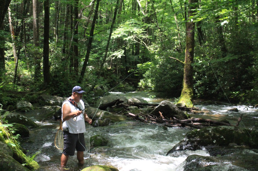
My first venture fishing in the Park was on a hike with the family. I brought along the fly rod and we started hiking up the Middle Prong Trail and fishing the Little River. This trail has a steady rise in elevation and for the most part, the Little River runs right along the trail. Although there were numerous places that had very easy access to the river finding a good spot to fish proved to be difficult. Due to the heavy rains the night before, the water was rushing through this narrow river. I stopped in a few places but the water just seem to be running too hard to get a drift going and forget wading; the rushing water and extremely slick rocks made it difficult to keep any sort of footing at all. After nearly falling in the rushing water more than a few times I gave up. I was done. I did enjoy the trail and the hike very much. The Little River is a beautiful stream and full of little water falls.

    I did realize that fishing in the mountain streams were a whole lot different than where I usually fish. I fish in wide, deep, slower moving tailwaters and streams. These require a long casts and a good long drift. Usually, you can stand and fish in the same spot for a long time. The river beds where I’m from are often sandy, gravel or rocky bottoms that are fairly easy to stand and move traverse. In contrast, the mountain streams are narrow, shallow, and fast moving. The rocks in the river bed range from pebble sized to boulders. Most have been rounded smooth by thousands of years of erosion and they are slick. I know rocks in water are usually slick, but these are crazy slick. Round rocks and river slim make walking in the river downright dangerous! Or, you could be walking along on some rocks and all of a sudden you can step into a crack that can swallow your entire leg. I learn rather quickly that mountain stream fishing is totally opposite of fishing the way I fish.

    img_7008

    Casting in a narrow mountain river requires extremely short casts. The guide at the Little River fly shop said to make about 3 casts in a spot then move upstream. In this fast narrow river, that takes approximately 30 seconds. The features in the river that hold fish are short and with the fast moving water a drift is over in seconds. So you are constantly casting and moving.  The problem is, if you are not used to moving over that type of terrain, it can be extremely difficult.

    I gotta tell you I was kind of surprised at the difficulty I experienced in fishing in the Smoky Mountains.

    The next evening, the whole crew went for ice cream. I was standing in line behind a guy that I could tell, just by looking at him, he was a fisherman. So, I struck up a conversation with him and sure I was right, he was a fisherman!  He said he’d grown up in a town near by and had been fishing the Smokies all his life. While we ate our cones, we talked about: fishing, fish, and trout. By the time the cones were gone, we had plans to meet up the next morning and go fishing. His name is Brandon Carr, he’s a softball coach with a passion for fly fishing and the Smoky Mountains. Some of you might find it odd that I made plans with a relative stranger to go fishing but my gut told me Brandon was good people. My gut is seldom wrong and it was not wrong about Brandon.

    img_0892

    In the morning I met with Brandon and we took the short drive to the Middle Prog Trail head, exactly the same trail that we had hiked and “fished” a couple of days before. (By the way, there is nothing cooler than riding into the mountains in a Jeep!) We parked the Jeep and started hiking up the trail along the stream. Now, I’m not the fittest guy in the world but I’m no couch potato either. I try to stay active by doing a little jogging, bicycling and we like to hike. But trying to keep up with Brandon took serious effort. What was cool about hiking with him, was that it was like having a person tour guy for the Smokies. I learned a lot of history about the logging company and how they used the stream and other resources available to them to move giant logs from the top of the mountain to the bottom.  We even paused a few times to look at different artifacts left behind by the loggers such as an old Cadillac and some rigging that helped anchor cables for moving logs. Most of which I would have missed if he had not pointed them out. As Brandon effortlessly bounded up this trail, I was happy he was doing all the talking and so I could just concentrate on keeping up. I’m not exactly sure how far we hiked, but I’m pretty sure it was close to three miles before he even suggested we wet a fly. Just like the guy the fly shop said, the high you go, the better the fishing. We also talked about what flies to fish, how to rig the flies and how to fish them. Pretty much exactly what the guys at the fly shop said. I was surprised to see how different the stream looked compared to the just two days before. The water was much clearer and the stream had slowed considerably. With the water not moving as fast, I thought that traversing the stream would be easier,  boy was I wrong.img_0883

    I started to cast and move, like I was supposed to… and wham, I caught a snag on the other side of a large pool and lost my flies. I survey the damage and discover I needed to retie my tippet as well as the flies. As I go to snip my 6x tippet off the spool, I realize that I can’t see it. Now I know I’m getting a little long in the tooth and it won’t be long before I’ll be needing to carry around reading glasses with me everywhere but that time has had not yet come for me. Well, not until THAT day. By this point the sun was up, it was a bright sunny day, or as far as I could tell it was… The thick forest canopy was filtering out some of the sun light. I don’t know a lot about the spectrum of light that the sun emits, but I can tell you that the  forest filters out the light that allows a human to see 100% fluorocarbon tippet. As I went to tie on my tippet, I could see the leader, but the tippet just wasn’t there. I could feel it but I couldn’t see it. It was like it was under some sort of evil spell of invisibility. I guess it was pretty obvious that I was struggling, because eventually Brandon came over and help my tie my flies on.

    img_7022With my rig finally being good to go, I was ready to get back to fishing! I got back in the water, because that’s is how I knew to do it (and how we do it back home…in the water.  I struggled to keep my footing on the rocks, making my casts and moving. Pretty soon, I began to realize that between the hiking and wading I was exhausted. Every time I’d look up to see Brandon, he’d be way up stream. Which is good, because I didn’t want to slow him down and I didn’t really want him to see just how badly I was struggling at just standing!  I decided to rest a little and just watch Brandon fish. I was amazed at how he moved along the stream and fished. Not in the water like I was attempting to do but on the rocks, pausing to cast in the shallowest of features and moving quickly. Brandon’s not a small guy, but he leapt from rock to rock with the grace of a mountain goat. I was amazed at how quickly he could cover the stream and moved onto the next feature to find fish in places that I thought couldn’t possibly hold anything. I also having trouble keeping my leader from being sucked back through my eyelets. In my tailwater world, we use long leaders 7 1/2 to 9 feet to get the fly deep into the water column. As I watched Brandon fish, I noticed that the leader he was using was much shorter and  his dropper was not nearly as dropped as mine was. I also watch how he was moving along the stream, not in the stream but on top of the rocks and along the banks, not in the water like I was trying to traverse the stream.

    img_7145I decided that I had to just stop and reassess what I was doing and how I was doing it. Against my better judgment I cut the flies off my line. I completely retied, fortunately for me, the sun was a little higher in the sky and I was able to see my fluorocarbon tippet well enough to tie my knots. I also tried to move on top of the stream and not in the stream. I fished features, that I thought couldn’t possibly hold fish… and then it happened, I got a strike. And another. And another. Finally I hooked up! I caught a wild native Appalachian Brook Trout. It was one of the most beautiful fish I’ve ever seen. It was small, only about 5 inches long, but to me it was a prize worthy of mounting! I’ve never worked so hard to catch a fish in my life. It was well worth it!

    img_0889

    I’d also like to say thanks again to my new friend Brandon Carr for letting me tag along with him. He’ll never know how much he taught me about the Smoky Mountains and catching wild native fish in mountains streams.

    wayne


    Happy Fishing!

    Wayne

  • Our Very Close Encounter With A Black Bear

    Our Very Close Encounter With A Black Bear

    This is a story that will now live forever in our family memories. I know our daughter, The Short Chic, will be passing this down to her kids and grandkids and retelling this story throughout her life. This is the story of the time we went hiking and almost got eaten by a bear in The Smoky Mountains.

    As our time in The Great Smoky Mountains was coming to an end, I had hoped for one final hike in Cades Cove. All week I had read the “warning” signs of bear activity in the park. Abraham Falls was always on that list. Abraham Falls was also on another list: that of great fishing places in the Smoky Mountains. Wayne was hoping to catch a fish, I was hoping for a bear sighting, so we set off to hike Abraham Falls on our last day in Townsend.

    Abraham falls6 The entire crew traveled to the welcome sign and the majority of them bid us adieu so they could hang out at the campsite and rest. Wayne, The Short Chic and I headed to Cades Cove. Going into this hike, we were a little ill prepared. We had eaten breakfast but had not had lunch. We did not pack snacks (because we were not hungry when we set out). We did not realize Abraham Falls was a 5 mile hike round trip (2.5 in/2.5 out). We did pack several water bottles but if I am honest, I carried in more photography equipment than anything.  I give you this background information so you will understand that after hiking the 2.5 miles into Abraham Falls we were HANGRY and to make matters worse, The Short Chic talked nonstop about having ice cream for lunch the entire hike!

    abraham falls5The Abraham Falls hike terrain is rocky, uneven, and generally follows the Abraham Creek although the creek is often not accessible due to the terrain of the forest. Wayne took his fly rod and practiced catching wild Appalachian Brooke Trout any chance he could access the creek. The path dipped and climbed as the terrain did and it took us through moments of no shade/full sun, to the coverage of dense tree canopy and full shade, as well as up and over a rocky ridge. Several times the path took us over offshoots of the creek where we walked over wooden log foot bridges.

    abraham falls2IMG_7159The falls were a welcome site after hiking 2.5 miles! Numerous hikers had shed their shoes and clothing (yes they had swimsuits on underneath their clothing) to wade and splash in the water below the falls. The Short Chic had fantasized about getting wet in the water the entire hike and as we walked up to the waters edge the first thing we saw were dual water snakes! Wayne may have spent some time fishing there but The Short Chic and I got no where near that water and kept a diligent eye open for any additional reptiles during our short stay!

    abraham falls3We chose not to linger for a long time at the Falls, we still had 2.5 miles to go to get back to our car and it was getting late. I think we began our return around 2:45-3:15 p.m.. The Short Chic started making up songs about food on the way back and first Wayne attempted to hush her but I had the thought that it was approaching dinner time….not just to us but for animals as well. We let her sing at the top of her lungs just to make our presence known. We also hiked in a very specific order: me, The Short Chic, and Wayne just in case any predators were eyeballing us and looking for our weakest member.

    abraham fallsAfter we passed the ridge line and about 45 minutes into our return I notice some wild blackberries growing along the trail. You should all know that I love wild blackberries and was so hungry that I started picking the berries and eating them right there on the spot. I did notice that the berries were small and most of the larger ones where not yet ripe. As I picked berries for myself, Wayne picked them and gave them to The Short Chic.  Wayne spied a larger ripe berry just an arms s t r e t c h off the path and he decided to reach and pick that one berry.

    I never saw her. I heard the noise first. Then I heard Wayne yell. He saw her. He heard her. Just as he was about to reach that berry, a black bear who was hiding in the blackberry bush let her presence be known by woofing at him. As I turned back up the trail, there was my husband doing some Fred Flintstones thing with his feet, trying to run but yet not being able to move. I see the people who were behind us on the trail turn and run one direction and others who were in front of us run away from us. We were left to defend our ground and ourselves against this bear not knowing if the bear was going to charge us or not.

    Abraham Falls10
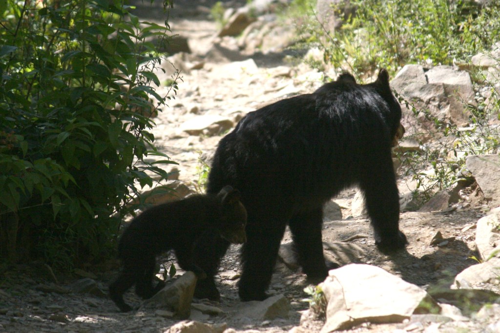
I grabbed The Short Chic’s arm and swung her around me. I stood as close to my husband as I could and in what felt like hours (but really was only a few seconds) we realized that bear had no interest in charging us; she wanted Wayne to leave her berries alone!

    Abraham falls8We moved safely up the trail. I am no judge of distance but we put enough space between that bear and us so that I felt safe. Ironically, that bear was completely hidden in the dense forest prior to letting us know she was there but after she gave us announced herself, we watched as that bear shook the living dickens out of the trees and the berry bushes. As the trees were shaking, we stopped everyone who was walking on the trail and explained there was a bear right there and I could see people up the trail hiding around a bend, their numbers growing as well.

    abraham falls7As we stood in safety waiting for our hearts to stop racing and for us to feel strength in our knees the next part of this story occurred. A baby bear walked down from the hill, crossed the trail, and went into the trees to the bear who woofed. The realization that we inadvertently had been standing/hiking in-between a momma bear and her cub hit us like a ton of bricks.

    Abraham falls9I think Momma Bear had been shaking that tree to knock the berries to the ground so Baby Bear could eat them with ease. A few moments after the Baby Bear joined the Momma Bear the shaking ceased. A few minutes later, both bears walked back onto the trail. Momma Bear never looked at us, she looked up the trail in the opposite direction of us but that Baby Bear turned and looked right in our direction. I had carried all of that camera equipment just hoping to spy a bear and here I was on the same trail and total strangers had to suggest taking photos!

    Abraham Falls11Momma Bear and Baby Bear walked up the trail away from us. In fact, just as they were reaching the bend with all the hikers hiding they turned to the forest and walked off the trail to not be seen again. It was as if time held still. I have no idea how long we all stayed in our safe spots before finally one of the hikers behind us came around the bend. I signaled where the bears had left the trail. He made it by safely so the masses decided to get finish the hike and get off the trail.

    abraham falls12The Short Chic never got her ice cream for lunch. By the time we got back it was nearing 5:00 p.m. and time for dinner. We met the rest of our party at PawPaw’s Kajun Kitchen in Sevierville on Wears Valley Road for some of the most amazing cajun food I have ever had. As we told our friends our story of the bears we guzzled sweet tea and munched on boudin balls and catfish. There was a lady sitting behind me who kept advising me on the menu so I struck up a conversation with her. Turns out she was the owners Momma visiting her daughter from New Orleans. Her accent was thick and she was a delight!  I gave her every opportunity to take credit for raising such an amazing cook but she never once did. We ended the night with the white chocolate bread pudding and left that place happy that the bear did not eat us so that we could enjoy such amazing food!